On New Year’s Eve 1857, Queen Victoria selected the location for the permanent capital of the Province of Canada. This turned out to be the small frontier town of Ottawa which had been founded in 1826 as Bytown, and incorporated as Ottawa in 1855. Its choice as capital came about for two main reasons: The town’s isolated location in a back country surrounded by dense forest far from the Canada–U.S. border and situated on a cliff face made it more defensible from attack and Ottawa was located approximately midway between Toronto and Kingston (in Canada West) and Montreal and Quebec City (in Canada East). Ottawa’s small size, it was thought, would make it less prone to rampaging politically motivated mobs, as had happened in the previous Canadian capitals. Ottawa was the only settlement of any substantial size that was already located directly on the border of French populated former Lower Canada and English populated former Upper Canada thus additionally making the selection an important political compromise.
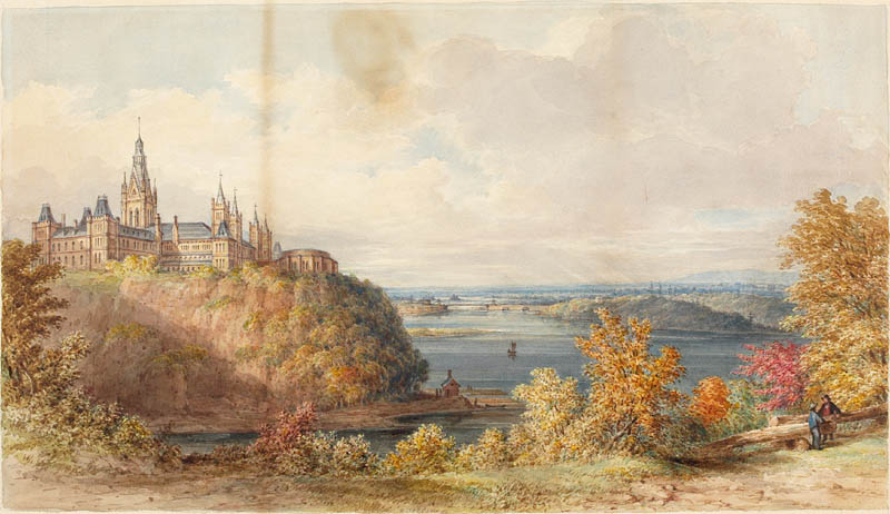
Barrack Hill was chosen as the site for the new parliament buildings, given its prominence over both the town and the river, as well as the fact that it was already owned by the Crown. The limestone outcrop with a gently sloping top was originally covered in primeval forest of beech and hemlock. For hundreds of years, the hill served as a landmark on the Ottawa River for First Nations and, later, European traders, adventurers, and industrialists, to mark their journey to the interior of the continent. After Ottawa — then called Bytown — was founded, the builders of the Rideau Canal used the hill as a location for a military base, naming it Barrack Hill. A large fortress was planned for the site, but was never built, and by the mid 19th century the hill had lost its strategic importance. Queen Victoria’s choice of Ottawa as the new capital initiated construction of Canada’s first parliament buildings on the hill. The first stage of this construction was completed in 1865, just in time to host the final session of the last parliament of the Province of Canada before Confederation.
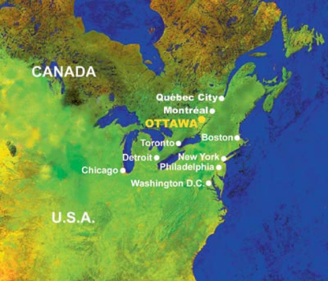
Ottawa stands on the south bank of the Ottawa River in the eastern portion of southern Ontario. The city borders Gatineau, Quebec; the two form the core of the Ottawa–Gatineau census metropolitan area (CMA) and the National Capital Region (NCR). As of 2016, Ottawa had a city population of 934,243 and a metropolitan population of 1,323,783 making it the fourth-largest city and the fifth-largest CMA in Canada.
Founded in 1826 as Bytown, and incorporated as Ottawa in 1855, the city has evolved into the political center of Canada. Its original boundaries were expanded through numerous annexations and were ultimately replaced by a new city incorporation and amalgamation in 2001 which significantly increased its land area. The city name Ottawa was chosen in reference to the Ottawa River, the name of which is derived from the Algonquin Odawa, meaning “to trade”.
Ottawa has the most educated population among Canadian cities and is home to a number of post-secondary, research, and cultural institutions, including the National Arts Centre, the National Gallery, and numerous national museums. Ottawa has the highest standard of living in the nation and low unemployment. It ranked 2nd nationally and 24th worldwide in the quality of life index and is consistently rated the best place to live in Canada.
With the draining of the Champlain Sea around 10,000 years ago the Ottawa Valley became habitable. The Algonquin people (Anishinaabe) who called the Ottawa River the Kichi Sibi or Kichissippi meaning “Great River” or “Grand River” maintained a trade route along the Ottawa River for a relatively short time. The Ottawa people hunted, camped, traded, and traveled in the area, and also lived far to the west along Georgian Bay and Lake Huron.
When Étienne Brûlé in 1610 became the first European to travel up the Ottawa River, followed by Samuel de Champlain in 1613, they were assisted by Algonquin guides. Written records show that by 1613 the Algonquins were in control of the Ottawa Valley and the surrounding areas to the west and north.

Champlain wrote about both the Rideau Falls (named by later canoeists) on the eastern part of the early future town, and the Chaudière Falls (named by Champlain) in the west, which would later become employed in the lumber industry. Unlike some parts of Gatineau, and areas much further upstream, there are no indications of any settlement at all in present-day Ottawa for the next two centuries. Chaudière was, and still is impassable by any water traffic, so there were portage paths around it on trips from the mouth of the Ottawa River to the lands of the interior and Great Lakes. Many missionaries, coureurs de bois and voyageurs passed by Ottawa, such as Jesuit martyr Jean de Brébeuf in 1634, on his way to the Hurons, Groseilliers in 1654, Radisson, and in the 1700s explorers La Vérendrye (who made four trips west in the 1730s and 1740s), and later Alexander Mackenzie, Joseph Frobisher and Simon McTavish. Nicholas Gatineau also traded using the nearby Gatineau River.
The Algonquin were not the only people in present-day Ontario. During the 17th century, the Algonquians and Hurons fought a bitter war against the Iroquois. Champlain’s travels brought him to Lake Nipissing and Georgian Bay to the center of Huron country near Lake Simcoe. During these voyages, Champlain aided the Hurons in their battles against the Iroquois Confederacy. As a result, the Iroquois would become enemies of the French and be involved in multiple conflicts (known as the French and Iroquois Wars) until the signing of the Great Peace of Montreal in 1701.

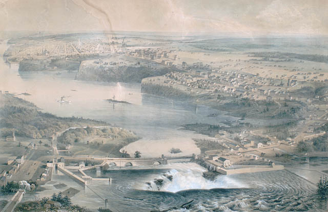
The first major European settlement near Ottawa was founded by Philemon Wright, a New Englander from Woburn, Massachusetts who, on March 7, 1800, arrived with his own and five other families along with twenty-five laborers. They started an agricultural community called Wright’s Town (now Gatineau, Quebec) on the north bank of the Ottawa River at the Chaudière Falls. Food crops were not sufficient to sustain the community and Wright began harvesting trees as a cash crop when he determined that he could transport timber by river from the Ottawa Valley to the Montreal and Quebec City markets, and onward to Europe. His first raft of squared timber and sawed lumber arrived in Quebec City in 1806. It was from this location that much of the future settlement on the south shore was facilitated. By this time, land on the Ottawa side of the river had already been surveyed and land grants were being issued.
In 1818, a settlement was formed at Richmond Landing, in present-day LeBreton Flats, while Richmond Road, Ottawa’s first thoroughfare was being built. Families of the English soldiers who came to create the settlement of Richmond stayed for months at this location which had had a store since 1809 erected by Jehiel Collins, who is credited as the first settler of what would become Bytown. In the intervening years, the area would see such settlers as Braddish Billings, Abraham Dow, Ira Honeywell, John LeBreton. and original owner of much of Ottawa’s early lands, Nicholas Sparks. Another major landholder was Lieutenant-Colonel John By, who oversaw the construction of the Rid

The first European survey of the Rideau Route, part of an indigenous canoe route that connected the Ottawa River to the St. Lawrence River at Gananoque, was conducted by Lt. Gershom French in 1783. On October 2, 1783, his survey party camped on the shores of the Rideau River at the head of the portage from the Ottawa River that led around Rideau Falls. He described the area as “the soil everywhere good and deep, timbered with Maple, Elm and Butternut”. The War of 1812 made evident the need for a safe military supply route from Montreal to Kingston so the Rideau Route was surveyed for the purposes of a canal, in 1816 by Royal Engineer Joshua Jebb and in 1823-24 by civil surveyor Samuel Clowes. In 1826, Lieutenant-Colonel John By was appointed to oversee its construction and he hired contractors that included Philemon Wright, who supplied much of the stone, mortar and labor, Thomas McKay, a mason, and staff such as John MacTaggart and Thomas Burrowes, surveyor, Burrowes’ created many paintings of early Bytown. The Governor General George Ramsay, the Earl of Dalhousie took a great interest in the construction of the canal, as well as in establishing a settlement in the area. On September 26, 1826, Colonel By and Dalhousie had agreed that the canal’s entrance was to be at Entrance Bay (its current location), and along with a letter authorizing Colonel By to divide the town into lots, marked the origins of what was to become the town of Bytown.
Dalhousie’s letter stated in part: “I take this opportunity of meeting you here to place in your hands a Sketch Plan of several Lots of Lands, which I thought advantageous to purchase for the use of Government, when this Canal was spoken of, as likely to be carried into effect, this not only contains the site for the Head Locks, but they offer a valuable locality for a considerable Village or Town, for the lodging of Artificers and other necessary Essentials, in so great a Work. I would propose that these be correctly surveyed, laid out in lots of 2 or so Acres, to be granted according to the means of settlers and to pay a Government rent of 2/6 per acre annually.”

By set up his base of operations in Wright’s Town, and began construction of the Union Bridge as a link to the new town. The Royal Sappers and Miners were employed in 1827 for the canal’s construction, which began at three separate places, one of them being the site of the locks in Ottawa. The workers were eventually moved into three barracks on today’s Parliament Hill, which was then known as Barracks Hill. In 1827, Sappers Bridge connecting the Upper Town (west of the canal) and Lower Town (east of the canal) was built over the Rideau Canal.
The Victoria Brewery was established in 1829, by John Rochester, senior, and James Rochester, in the brewing of ale and porter. By 1866, it was conducted on Richmond Road, by John Rochester, junior. The Chaudiere Brewery, which was established in 1858, was carried on by Parris & Smith by 1865. By 1866, Mr. Sterling operated a brewery at the foot of Rideau Locks while Dr. Doyle operated a brewery on Sussex Street.
A steady stream of Irish immigration to Eastern Ontario (already well underway) in the next few decades, along with French Canadians who crossed over from Quebec, provided the bulk of workers involved in the Rideau Canal project and the timber trade. The canal was dubbed the Rideau Canal when it was finally completed in 1832. Colonel By laid out the town, most of his original street plans remain today.

To manufacture carriages and wagons, Peter Dufour established a carriage works in 1832; the Royal Carriage Factory was established in 1840 by George Humphries; Wm. Stockdale & Brother’s on Rideau Street was established in 1854. Perkins’ Foundry on Sparks Street was established in 1840 by Lyman Perkins to manufacture steam engines, boilers and mill machinery; The City Foundry was established in 1848 by T. M. Blasdell to manufacture Mill machinery and agricultural implements. James McCullough, established a tannery in 1860 to turn out leath
Former Bytown mayor and cabinet minister, Richard William Scott recalled that in early 1850,
“Neither Wellington, nor the streets south of it, between Elgin and Bank, had been laid out. Sussex was the business thoroughfare, and lots on it and the western ends of Rideau, George, and parallel streets, as far north as St. Patrick Street, commanded the best values. Wellington west of Bank, to Bay Street, was fairly well built up. The Le Breton Flats, extending north-westerly from Pooley’s Bridge (in the vicinity of the Water Works building) contained a number of scattered houses.”
The timber trade spurred the growth of Bytown, and it saw an influx of immigrants, and later entrepreneurs hoping to profit from the squared timber that would be floated down the Ottawa River to Quebec. Bytown had seen some trouble in the early days, first with the Shiners’ War in 1835 to 1845, and the Stony Monday Riot in 1849.
![[url=https://flic.kr/p/Do8cd6][img]https://farm5.staticflickr.com/4638/24535566817_85f3909841_o.jpg[/img][/url][url=https://flic.kr/p/Do8cd6]1855_Colton_Map_of_Upper_Canada_or_Ontario_-_Geographicus_-_Ontario2-colton-1855[/url] by [url=https://www.flickr.com/photos/am-jochim/]Mark Jochim[/url], on Flickr](https://farm5.staticflickr.com/4638/24535566817_85f3909841_o.jpg)
The St. Lawrence and Ottawa Railway and Bytown and Prescott Railway linked the town to the outside world in 1854 after a lot of expense and later huge losses by the city. Bytown, now no longer a town, was renamed and the City of Ottawa was incorporated seven days later on January 1, 1855. Though the suggestion to give the city an aboriginal name had been published as early as 1844, Mayor Turgeon and Municipal Council proposed the name Ottawa to mark the 200th anniversary of the Ottawa people employing the river once again to come to Montreal for trade reasons. The river had been unused for about five years for fear of attack but an 1854 truce with the Iroquois allowed its reuse. While the event itself was not highly significant, it gave the name a historical context.
In 1841, Upper Canada ceased to exist as present-day southern Quebec joined present-day southern Ontario to form the Province of Canada. The location of the capital city changed six times in its 26-year history. The first capital was in Kingston (1841–1844) before it was moved to Montreal (1844–1849). Rioters, spurred by a series of incendiary articles published in The Gazette, protested the Rebellion Losses Bill and burned down Montreal’s parliament buildings. It then moved to Toronto (1849–1852), Quebec City from 1852 to 1856, Queen Victoria was asked to choose a more permanent location, selecting Ottawa on December 31, 1857. During construction of its parliament and other buildings, the government met in Toronto for one year (1858) before returning to Quebec City from 1859 to 1866.
Barrack Hill in Ottawa was chosen as the site for the new Parliament buildings, given its prominence over both the town and the river. On May 7, 1858, the Department of Public Works issued a call for design proposals for the new parliament buildings to be erected on Barrack Hill, which was answered with 298 submitted drawings. After the entries were narrowed down to three, Governor General Sir Edmund Walker Head was approached to break the stalemate, and the winners were announced on August 29, 1859.
The Centre Block, departmental buildings, and a new residence for the governor general were each awarded separately. The team of Thomas Fuller and Chilion Jones, under the pseudonym of Semper Paratus, won the prize for the first category with their Victorian High Gothic scheme of a formal, symmetrical front facing a quadrangle, and a more rustic, picturesque back facing the escarpment overlooking the Ottawa River. The team of Thomas Stent and Augustus Laver, under the pseudonym of Stat nomen in umbra, won the prize for the second category, which included the East and West Blocks. These proposals were selected for their sophisticated use of Gothic architecture, which was thought to remind people of parliamentary democracy’s history, would contradict the republican Neoclassicism of the United States’ capital, and would be suited to the rugged surroundings while also being stately. $300,000 was allocated for the main building, and $120,000 for each of the departmental buildings.
Ground was broken on December 20, 1859, and the first stones laid on April 16 of the following year. Prince Albert Edward, Prince of Wales (later King Edward VII), laid the cornerstone of the Centre Block on September 1, 1860. At the time, this was the largest North American construction project ever attempted and Public Works Canada and its architects were not initially well prepared. The Library of Parliament and Parliament Hill landscaping would not be completed until
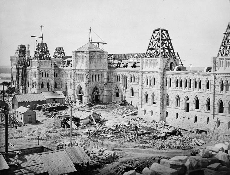
Workers hit bedrock earlier than expected, necessitating blasting in order to complete the foundations, which had also been altered by the architects in order to sit 17 feet (5.25 meters) deeper than originally planned. By early 1861, Public Works reported that $1,424,882.55 had been spent on the venture, leading to the site being closed in September and the unfinished structures covered in tarpaulins until 1863, when construction resumed following a commission of inquiry.
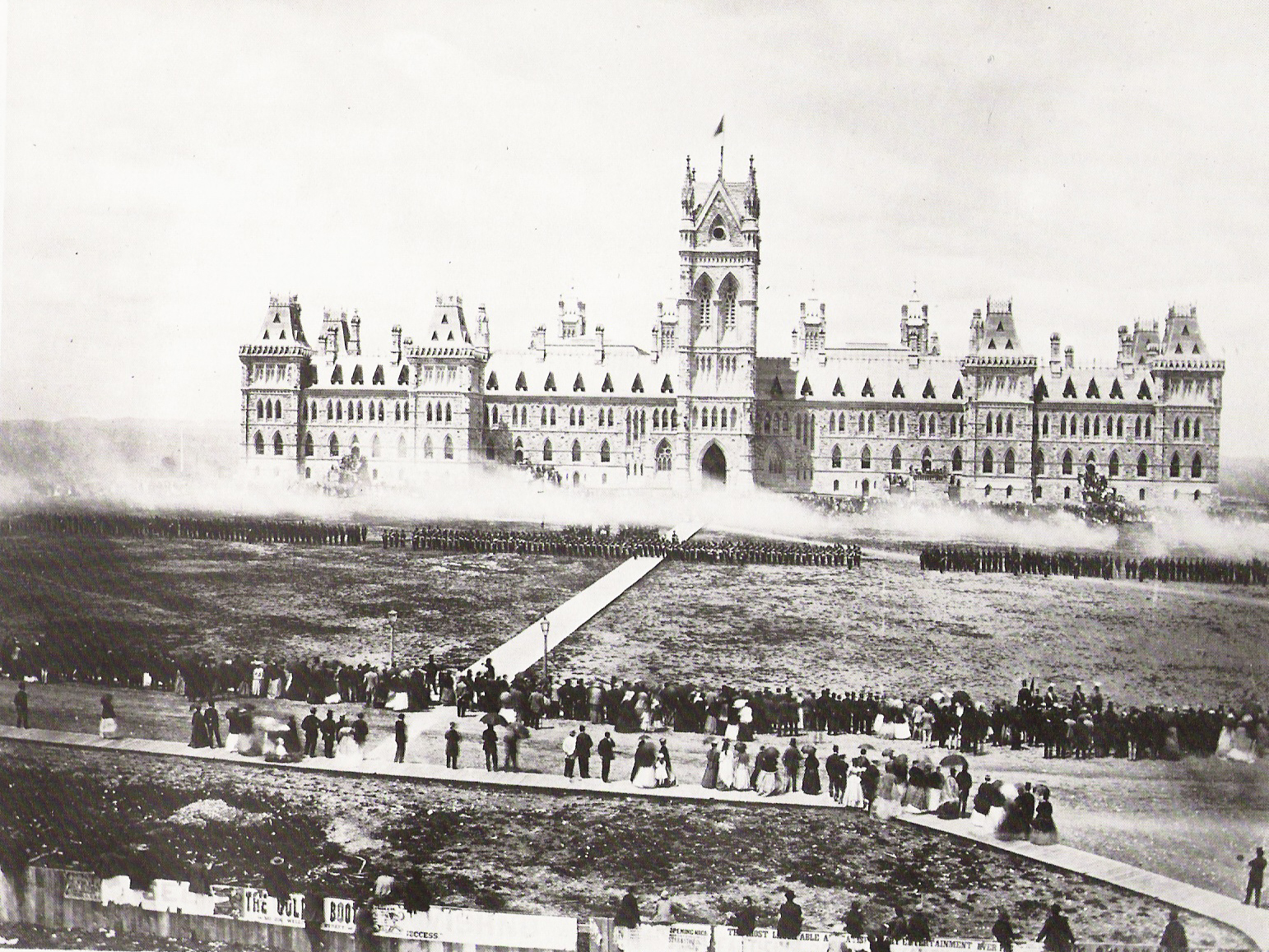
Two years later, the unfinished site hosted a celebration of Queen Victoria’s birthday, further cementing the area’s position as the central place for national outpouring. The site was still incomplete when three of the British North American colonies (now the provinces of Ontario, Quebec, Nova Scotia, and New Brunswick) entered the Canadian Confederation in 1867, with Ottawa remaining the capital of the new country. Within four years Manitoba, British Columbia, Prince Edward Island, and the North-West Territories (now Alberta, Saskatchewan, Yukon, Northwest Territories, and Nunavut) were added and, along with the associated bureaucracy, the first three required representation be added in parliament. Thus, the offices of parliament spread to buildings beyond Parliament Hill even at that early date.
The British military gave a nine-pound naval cannon to the British army garrison stationed in Ottawa in 1854. It was purchased by the Canadian government in 1869 and fired on Parliament Hill for many years as the “Noonday Gun”.
By 1876, the structures of Parliament Hill were finished, along with the surrounding fence and gates. However, the grounds had yet to be properly designed; Governor General the Marquess of Dufferin and Ava sent chief architect Thomas Scott to New York City to meet with Calvert Vaux and view Central Park. Vaux completed a layout for the landscape of Parliament Hill, including the present day driveways, terraces, and main lawn, while Scott created the more informal grounds to the sides of and behind the buildings. In 1901, they were the site of official ceremonies in January of that year following Queen Victoria’s death and in late September when Victoria’s grandson, Prince George, Duke of Cornwall (later King George V), dedicated the large statue that stands on the hill in the late queen’s honor.
During the construction of the Parliament buildings in Ottawa, the sawed lumber industry had supplanted the squared timber trade when an influx of mostly American lumber barons decided that more money could be made if the timber was actually sawed. Mills began to be constructed; some of Canada’s largest sawmills were located near the Chaudière Falls. Notable lumber barons in this area were Henry Franklin Bronson and John Rudolphus Booth. The lumber industry contributed to Ottawa’s growth, and evidence of it is practically nonexistent today. The major portion of this industry lasted until shortly after the turn of the century, the decline being caused by decreased markets for lumber due to the switch to steel, Britain no longer subsidizing the market, and reduced supplies of uncut timber. During a time of stagnation in manufacturing and a decrease in the city’s industrialization, the city would see new government departments being formed and large increases in public service employment following 1900.
Legislation enacted in 1870 as “An Act respecting certain Works on the Ottawa River” remains in effect to this day and mandates that the River and “all canals or other cuttings for facilitating such navigation, and all dams, slides, piers, booms, embankments and other works of what kind or nature soever in the channel or waters of the said River” fall under the exclusive jurisdiction of the Parliament at Ottawa, which now delegates this responsibility to the Minister of Public Works and Government Services.
By 1885 Ottawa was the only city in Canada whose downtown street lights were powered entirely by electricity. In 1889, the Government developed and distributed 60 “water leases” (still currently in use) to mainly local industrialists which gave them permission to generate electricity and operate hydroelectric generators at Chaudière Fall
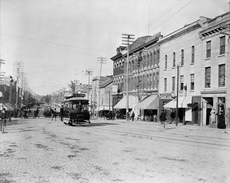
A vast public transportation network was started when Thomas Ahearn founded the Ottawa Electric Railway Company in 1893, replacing a horsecar system which began in 1870. This private enterprise eventually provided heated streetcar service covering areas such as Brittania, Westboro, The Glebe, Rockcliffe Park and Old Ottawa South.
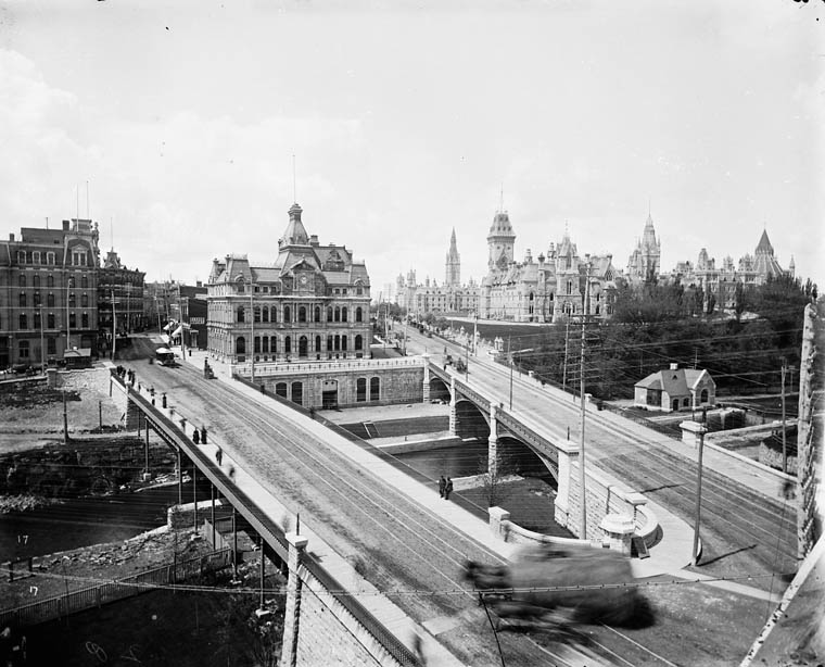
Ottawa became part the transcontinental rail network on June 28, 1886, when Pacific Express connected it to Hull, Quebec (now Gatineau) and then onto Lachute, Quebec via the Prince of Wales Bridge. For years, Ottawa was crisscrossed by the railways of several companies which had stations such as the Bytown and Prescott Railway in New Edinburgh, Broad Street in Lebreton Flats, and two others. A downtown central station was first created in 1895 through John Rudolphus Booth’s Canada Atlantic Railway. The site was later used for Union Station, which opened in June 1912 to little fanfare, since Grand Trunk Railway general manager Charles Hays perished in the Titanic disaster two months previously. Though removed in 1966, the tracks had led along the east side of the canal towards downtown to Union Station, then alongside Chateau Laurier running to the Alexandra (Interprovincial) Bridge.
[url=https://flic.kr/p/21G6gg2][img]https://farm5.staticflickr.com/4637/38522379275_1a20f2c826_o.jpg[/img][/url][url=https://flic.kr/p/21G6gg2]Ottawa_Post_Office_Sappers_Bridge_Dufferin_Bridge2[/url] by [url=https://www.flickr.com/photos/am-jochim/]Mark Jochim[/url], on Flick
The Hull-Ottawa fire of 1900 destroyed two thirds of Hull, including 40 per cent of its residential buildings and most of its largest employers along the waterfront. The fire also spread across the Ottawa River and destroyed about one fifth of Ottawa from the Lebreton Flats south to Booth Street and down to Dow’s Lake.
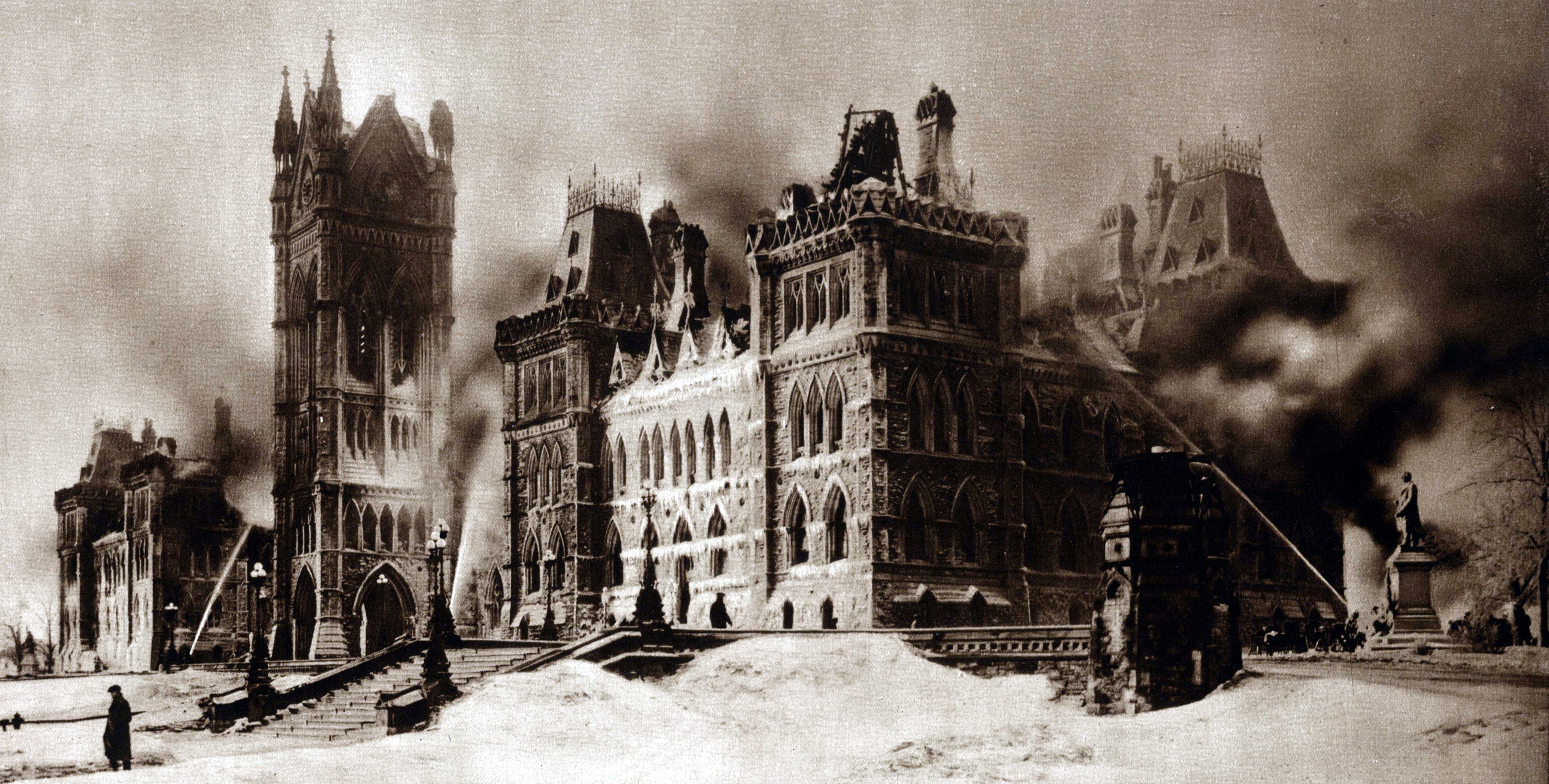
The Centre Block of the Parliament buildings were destroyed by fire on February 3, 1916. The House of Commons and Senate were temporarily relocated to the recently constructed Victoria Memorial Museum, now the Canadian Museum of Nature. Despite the ongoing war, the original cornerstone was re-laid by Governor General Prince Arthur, Duke of Connaught, on September 1, 1916; exactly fifty-six years after his brother, the future King Edward VII, had first set it. The new Centre Block was completed in 1922, the centerpiece of which is a dominant Gothic revival-styled structure known as the Peace Tower, in commemoration of the Canadians who had lost their lives during the First World War.
The current location of what is now known as Confederation Square was a former commercial district centrally located in a triangular area downtown surrounded by historically significant heritage buildings which includes the Parliament buildings. It was redeveloped as a ceremonial center in 1938 as part of the City Beautiful Movement and became the site of the National War Memorial in 1939 and designated a National Historic Site in 1984. A new Central Post Office (currently the Privy Council of Canada) was constructed in 1939 beside the War Memorial because the original post office building located on the proposed Confederation Square grounds had to be demolished.
The Hill hosted a number of significant events in Canadian history, including the first visit of the reigning Canadian sovereign — King George VI, with his consort, Queen Elizabeth — to his Parliament, on May 19, 1939. VE Day was marked with a huge celebration on May 8, 1945, the first raising of the country’s new national flag took place there on February 15, 1965, the centennial of Confederation was celebrated on July 1, 1967, and the Silver Jubilee of Queen Elizabeth II was marked on October 18, 1977. The Queen was back on Parliament Hill on April 17, 1982, to issue a royal proclamation of the enactment of the Constitution Act that year. Crowds marked the beginning of the third millennium with a large ceremony on the quadrangle and the “largest single vigil” ever seen in the nation’s capital took place in 2001, when 100,000 people gathered on the main lawn to honor the victims of the September 11 attacks on the United States that year. The following year, Queen Elizabeth II’s Golden Jubilee was marked on October 13, as was her Diamond Jubilee on February 6 (Accession Day) 2012.

Ottawa’s former industrial appearance was vastly altered by the 1950 Greber Plan. Prime Minister Mackenzie King hired French architect-planner Jacques Greber to design an urban plan for managing development in the National Capital Region, to make it more aesthetically pleasing and thus more befitting a location serving as Canada’s political center. Greber’s plan included the creation of the National Capital Greenbelt, the Parkway, the Queensway highway system, the relocation of downtown Union Station (now the Government Conference Centre) to the suburbs, the removal of the street car system, the decentralization of selected government offices, the relocation of industries and removal of substandard housing from the downtown and the creation of the Rideau Canal and Ottawa River pathways to name just a few of its recommendations.
In 1958, the National Capital Commission was established as a Crown Corporation from the passing of the National Capital Act to implement the Greber Plan recommendations-which it successfully accomplished during the 1960s and 1970s. In the previous 50 years, other commissions, plans and projects had failed to implement plans to improve the capital such as the 1899 Ottawa Improvement Commission (OIC), The Todd Plan in 1903, The Holt Report in 1915 and The Federal District Commission (FDC) established in 1927. In 1958, a new City Hall opened on Green Island near Rideau falls where urban renewal had recently transformed this former industrial location into green space. Until then, City Hall had temporarily been located for 27 years (1931–1958) at the Transportation Building adjacent to Union Station and now part of the Rideau Centre. In 2001, Ottawa City Hall moved back downtown to a relatively new building (1990) on 110 Laurier Avenue West, the prior home of the now defunct Regional Municipality of Ottawa-Carleton. This new downtown location was very close to Ottawa’s first (1849–1877) and second (1877–1931) City Halls. This new city hall complex also contained an adjacent 19th century restored heritage building formerly known as the Ottawa Normal School
From the 1960s until the 1980s, the National Capital Region experienced a building boom, which was followed by large growth in the high-tech industry during the 1990s and 2000s. Ottawa became one of Canada’s largest high tech cities and was nicknamed Silicon Valley North. By the 1980s, Bell Northern Research (later Nortel) employed thousands, and large federally assisted research facilities such as the National Research Council contributed to an eventual technology boom. The early adopters led to offshoot companies such as Newbridge Networks, Mitel and Corel.
Ottawa’s city limits had been increasing over the years, but it acquired the most territory on 1 January 2001, when it amalgamated all the municipalities of the Regional Municipality of Ottawa–Carleton into one single city. Regional Chair Bob Chiarelli was elected as the new city’s first mayor in the 2000 municipal election, defeating Gloucester mayor Claudette Cain. The city’s growth led to strains on the public transit system and on road bridges. On October 15, 2001, a diesel-powered light rail transit (LRT) line was introduced on an experimental basis. Known today as the Trillium Line, it was dubbed the O-Train and connected downtown Ottawa to the southern suburbs via Carleton University. The decision to extend the O-Train, and to replace it with an electric light rail system was a major issue in the 2006 municipal elections where Chiarelli was defeated by businessman Larry O’Brien. After O’Brien’s election transit plans were changed to establish a series of light rail stations from the east side of the city into downtown, and for using a tunnel through the downtown core. Jim Watson, the last mayor of Ottawa prior to amalgamation, was re-elected in the 2010 election.
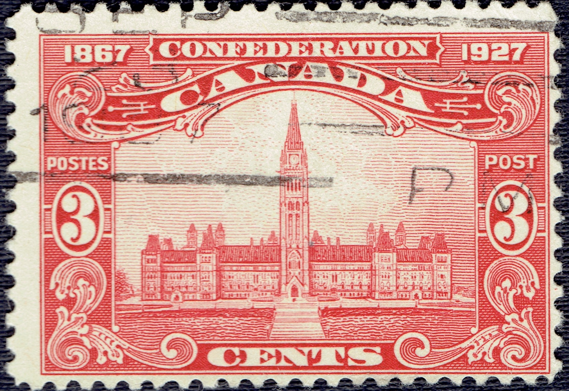
In October 2012, City Council approved the final Lansdowne Park plan, an agreement with the Ottawa Sports and Entertainment Group that saw a new stadium, increased green space, and housing and retail added to the site. In December 2012, City Council voted unanimously to move forward with the Confederation Line, a 12.5 km light rail transit line, to be fully operational by 201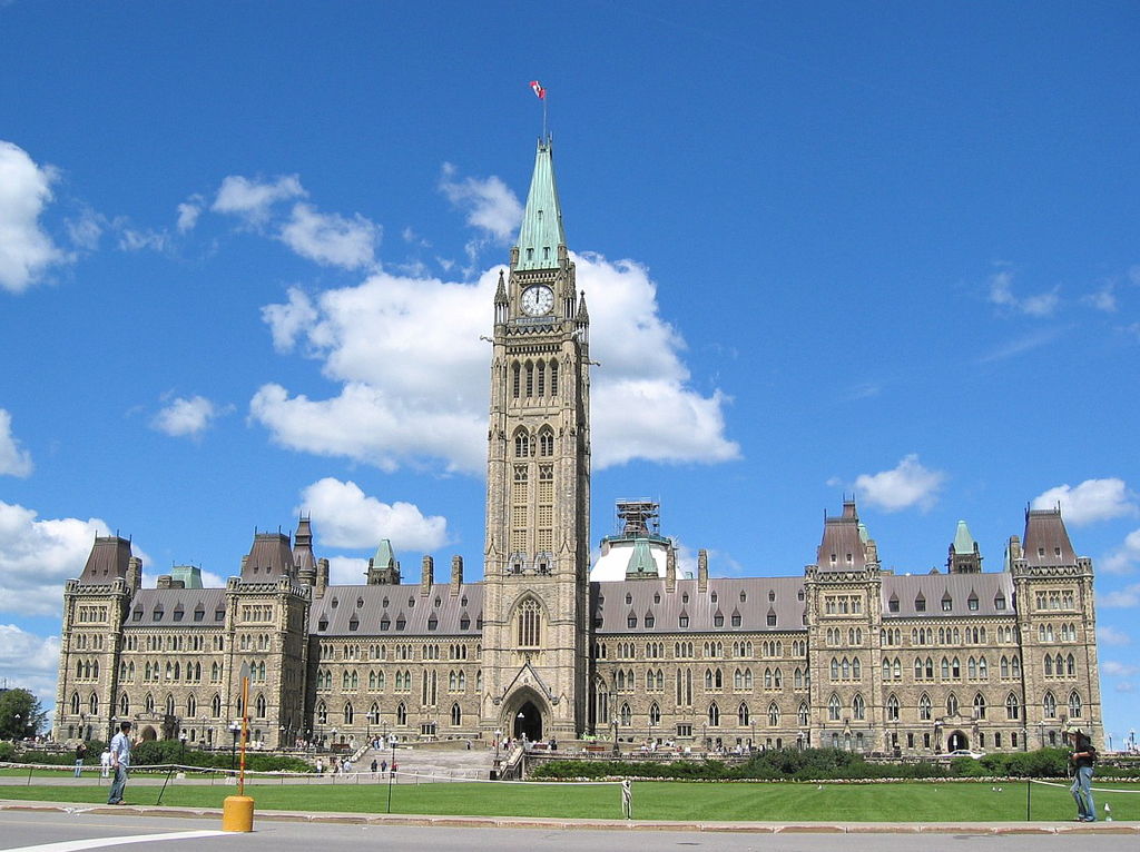 A number of stamps have been issued over the course of the past 90 years portraying the Parliament buildings, beginning with Scott #143 which was released on June 29, 1927. It was part of a set of five stamps commemorating the 60th anniversary of the Canadian Confederation (Scott #141-145). The 3-cent brown carmine stamp was engraved by the Canadian Bank Note Company, perforated 12.