


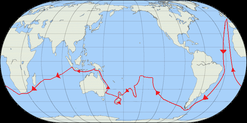
On August 26, 1768, the British Royal Navy ship HMS Endeavour departed from Plymouth-Dock (Devonport), England, carrying 94 people and 18 months of provisions starting the first of three Pacific voyages of which James Cook was the commander. The aims of this expedition were to observe the transit of Venus across the Sun (June 2-3, 1769) and to seek evidence of the postulated Terra Australis Incognita or “unknown southern land”.
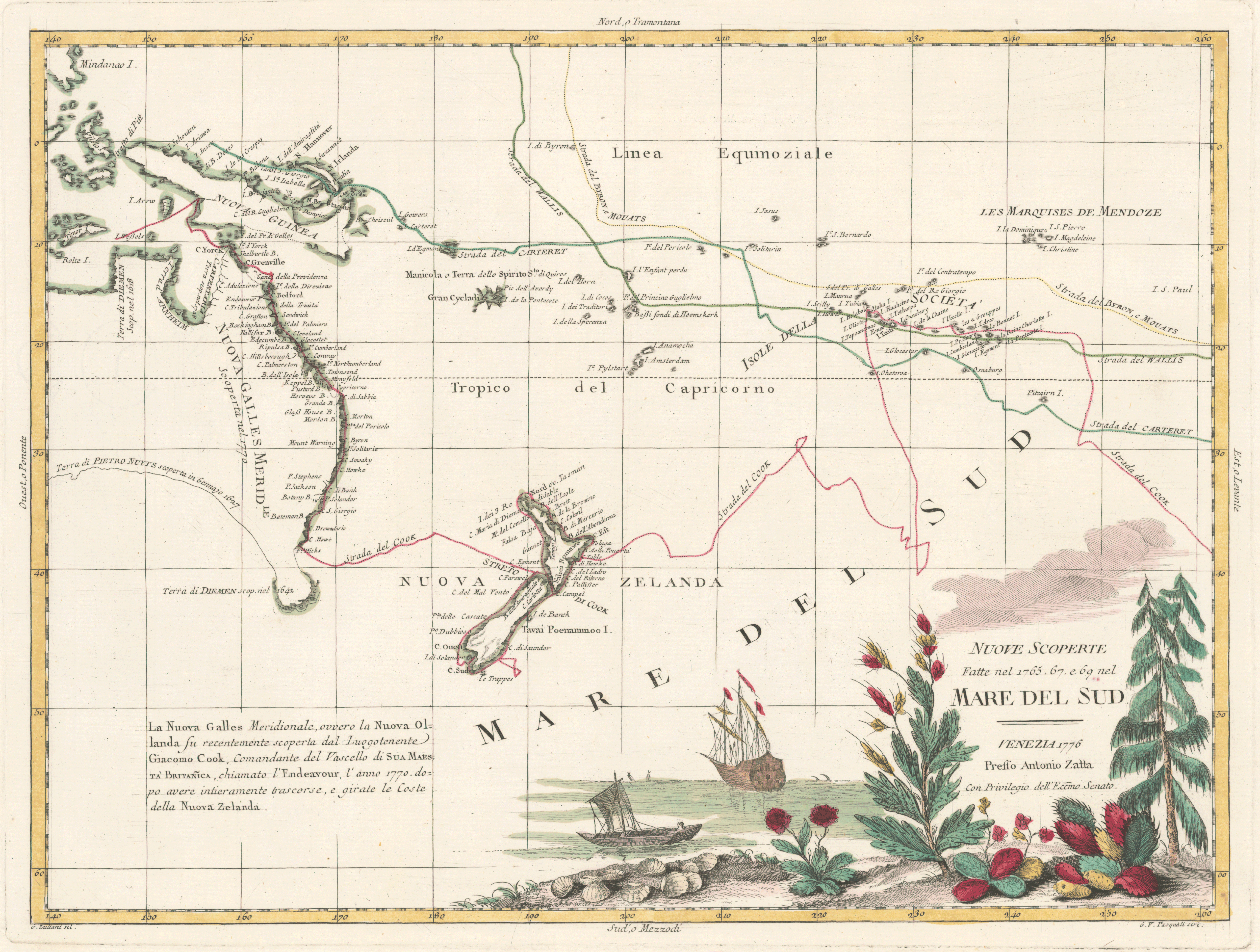
The voyage was commissioned by King George III and commanded by Lieutenant James Cook, a junior naval officer with good skills in cartography and mathematics. The expedition crossed the Atlantic, rounded Cape Horn and reached Tahiti in time to observe the transit of Venus. Cook then set sail into the largely uncharted ocean to the south, stopping at the Pacific islands of Huahine, Borabora and Raiatea to claim them for Great Britain, and unsuccessfully attempting to land at Rurutu. In September 1769 the expedition reached New Zealand, being the second Europeans to visit there, following the first European discovery by Abel Tasman 127 years earlier. Cook and his crew spent the following six months charting the New Zealand coast, before resuming their voyage westward across open sea. In April 1770 they became the first Europeans to reach the east coast of Australia, making landfall at Point Hicks, and then proceeding to Botany Bay.
The expedition continued northward along the Australian coastline, narrowly avoiding shipwreck on the Great Barrier Reef. In October 1770, the badly damaged Endeavour came into the port of Batavia in the Dutch East Indies, her crew sworn to secrecy about the lands they had discovered. They resumed their journey on December 26, rounded the Cape of Good Hope on March 13, 1771, and reached the English port of Deal on July 12. The voyage lasted almost three years.
The year following his return, Cook set out on a second voyage of the Pacific, which lasted from 1772 to 1775. His third and final voyage lasted from 1776 to 1779.
I believe I first became interested in James Cook upon the release of two stamps by the United States on January 20, 1978, commemorating his visits to Hawaii and Alaska (Scott #1732-1733). I was a 12-year-old stamp collector living in northeast Kansas and had recently read a copy of Samuel Eliot Morison’s biography of Christopher Columbus, Admiral of the Ocean Seas — a gift from my grandfather. The previous year, my mother had given me a subscription to the Postal Commemorative Society and I loved the beautifully-engraved Artcraft cachets on the first day covers (the first one I’d received was Scott #1710 marking the 50th anniversary of Lindbergh’s flight). When the covers for the Cook stamps arrived, I was impressed with their beauty (possibly the first time I really noticed the superiority of engraving on stamps). The interests in philately and history (not to mention geography) that I developed around that time have remained with me throughout my life. Stamps portraying James Cook and his explorations comprised one of the first topical collections I began as a young collector.
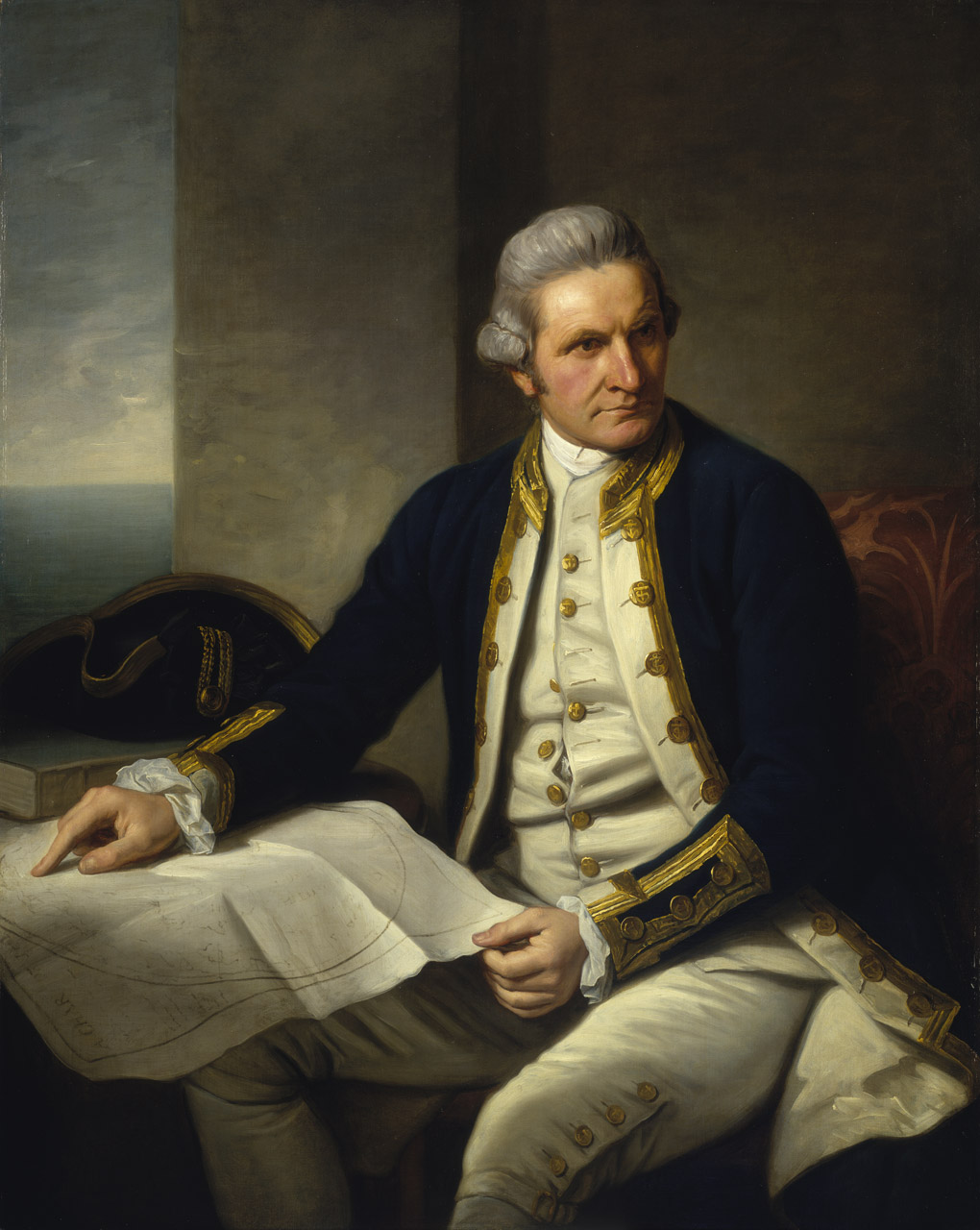
Born on November 7, 1728, in the village of Marton in Yorkshire, England, Cook joined the British merchant navy as a teenager and joined the Royal Navy in 1755. He saw action in the Seven Years’ War, and subsequently surveyed and mapped much of the entrance to the Saint Lawrence River during the siege of Quebec. This helped bring him to the attention of the Admiralty and the Royal Society. This notice came at a crucial moment in both Cook’s career and the direction of British overseas exploration, and led to his commission in 1766 as commander of HM Bark Endeavour for the first of three Pacific voyages.
During these voyages, Cook sailed thousands of miles across largely uncharted areas of the globe. He mapped lands from New Zealand to Hawaii in the Pacific Ocean in greater detail and on a scale not previously achieved. As he progressed on his voyages of discovery he surveyed and named features, and recorded islands and coastlines on European maps for the first time. He displayed a combination of seamanship, superior surveying and cartographic skills, physical courage and an ability to lead men in adverse conditions.
Cook was attacked and killed while attempting to kidnap the native chief of Hawaii during his third exploratory voyage in the Pacific on February 14, 1779. He left a legacy of scientific and geographical knowledge which was to influence his successors well into the 20th century, and numerous memorials worldwide have been dedicated to him.
On February 16, 1768, the Royal Society petitioned King George III to finance a scientific expedition to the Pacific to study and observe the 1769 transit of Venus across the sun to enable the measurement of the distance from the Earth to the Sun. Royal approval was granted for the expedition, and the Admiralty elected to combine the scientific voyage with a confidential mission to search the south Pacific for signs of the postulated continent Terra Australis Incognita (or “unknown southern land”). The aims of the expedition were revealed in the press: “To-morrow morning Mr. Banks, Dr. Solano [sic], with Mr. Green, the Astronomer, will set out for Deal, to embark on board the Endeavour, Capt. Cook, for the South Seas, under the direction of the Royal Society, to observe the Transit of Venus next summer, and to make discoveries to the South and West of Cape Horn”.
The London Gazetteer was more explicit when it reported on August 18, 1768: “The gentlemen, who are to sail in a few days for George’s Land, the new discovered island in the Pacific ocean, with an intention to observe the Transit of Venus, are likewise, we are credibly informed, to attempt some new discoveries in that vast unknown tract, above the latitude 40”. Another article reported that “the principal and almost sole national advantage” of the island discovered by Captain Wallace, that is Tahiti, was “its situation for exploring the Terra Incognita of the Southern Hemisphere”, and that, “The Endeavour, a North-Country Cat, is purchased by the Government, and commanded by a Lieutenant of the Navy; she is fitting out at Deptford for the South Sea, thought to be intended for the newly discovered island.”
The Royal Society suggested command be given to Scottish geographer Alexander Dalrymple, whose acceptance was conditional on a brevet commission as a captain in the Royal Navy. However, First Lord of the Admiralty Edward Hawke refused, going so far as to say he would rather cut off his right hand than give command of a Navy vessel to someone not educated as a seaman. In refusing Dalrymple’s command, Hawke was influenced by previous insubordination aboard the sloop HMS Paramour in 1698, when naval officers had refused to take orders from civilian commander Dr. Edmond Halley. The impasse was broken when the Admiralty proposed James Cook, a naval officer with a background in mathematics and cartography. Acceptable to both parties, Cook was promoted to Lieutenant and named as commander of the expedition.
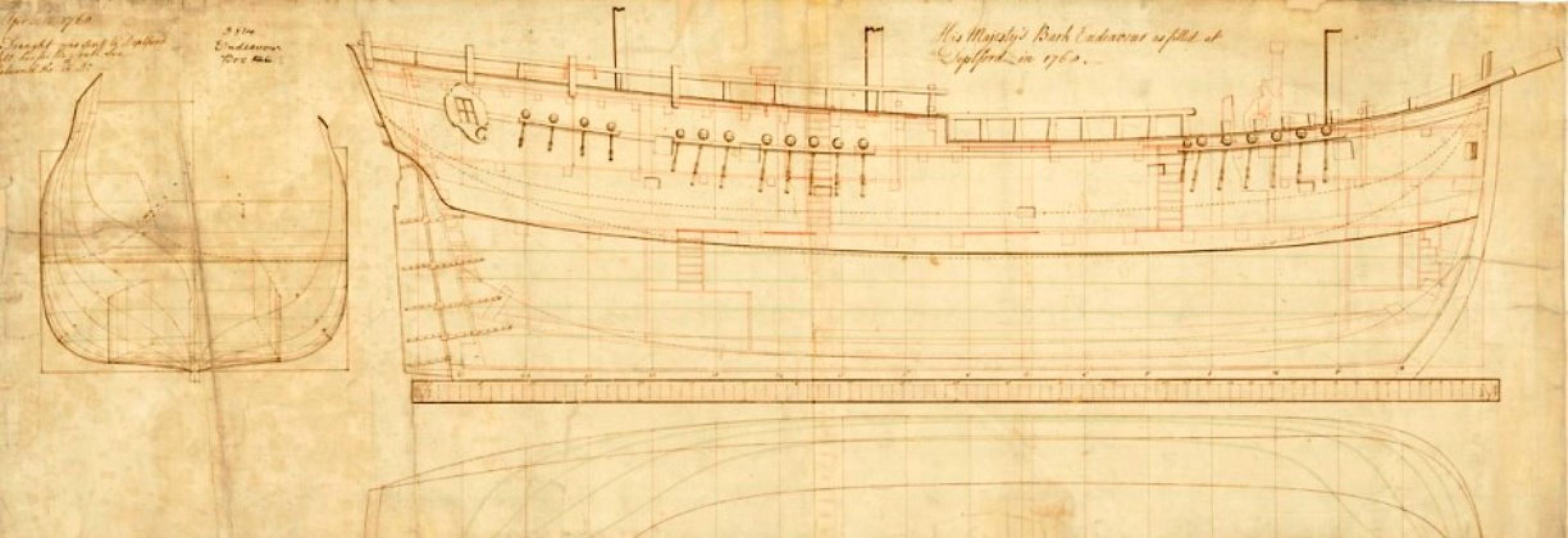
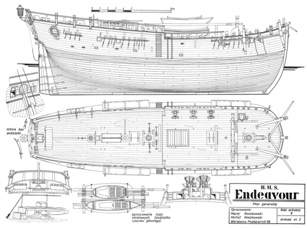
The vessel chosen by the Admiralty for the voyage was a merchant collier named Earl of Pembroke, launched in June 1764 from the coal and whaling port of Whitby in North Yorkshire. She was ship-rigged and sturdily built with a broad, flat bow, a square stern and a long box-like body with a deep hold. A flat-bottomed design made her well-suited to sailing in shallow waters and allowed her to be beached for loading and unloading of cargo and for basic repairs without requiring a dry dock. Her length was 106 feet (32 meters), with a beam of 29 feet 3 inches (8.92 m), and measuring 368 71⁄94 tons burthen.
Earl of Pembroke was purchased by the Admiralty in May 1768 for £2,840 10s 11d and sailed to Deptford on the River Thames to be prepared for the voyage. Her hull was sheathed and caulked, and a third internal deck installed to provide cabins, a powder magazine and storerooms. A longboat, pinnace and yawl were provided as ship’s boats, as well as a set of 28-foot (8.5 m) sweeps to allow the ship to be rowed if becalmed or demasted. After commissioning into the Royal Navy as His Majesty’s Bark the Endeavour, the ship was supplied with ten 4-pounder cannons and twelve swivel guns, for defense against native attack while in the Pacific.
Provisions loaded at the outset of the voyage included 6,000 pieces of pork and 4,000 of beef, nine tons of bread, five tons of flour, three tons of sauerkraut, one ton of raisins and sundry quantities of cheese, salt, peas, oil, sugar and oatmeal. Alcohol supplies consisted of 250 barrels of beer, 44 barrels of brandy and 17 barrels of rum.
On July 30, 1768. the Admiralty authorized a ship’s company for the voyage, of 73 sailors and 12 Royal Marines. The voyage was commanded by 40-year-old Lieutenant James Cook. His second lieutenant was Zachary Hicks, a 29-year-old from Stepney with experience as acting commander of the Hornet, a 16-gun cutter. The third lieutenant was John Gore, a 16-year Naval veteran who had served as master’s mate aboard HMS Dolphin during its circumnavigation of the world in 1766.
Other notable people on the expedition include the official astronomer, Charles Green, then assistant to the Astronomer Royal, Nevil Maskelyne. Joseph Banks had been appointed to the voyage as the official botanist. Banks funded seven others to join him: a Swedish naturalist Daniel Solander, a Finnish naturalist Herman Spöring, two artists, a scientific secretary, and two black servants from his estate.
Cook departed from Plymouth on August 26, 1768, carrying 94 people and 18 months of provisions. The Endeavour stopped at Madeira for more supplies, including three thousand gallons of wine, before proceeding across the Atlantic, reaching Rio de Janeiro in November. The Portuguese viceroy was suspicious of the ship’s scientific nature and would not allow anyone ashore. At night, Banks and his men surreptitiously landed and brought back large numbers of plants and specimens for examination, including what was later named the Bougainvillea after the French explorer.
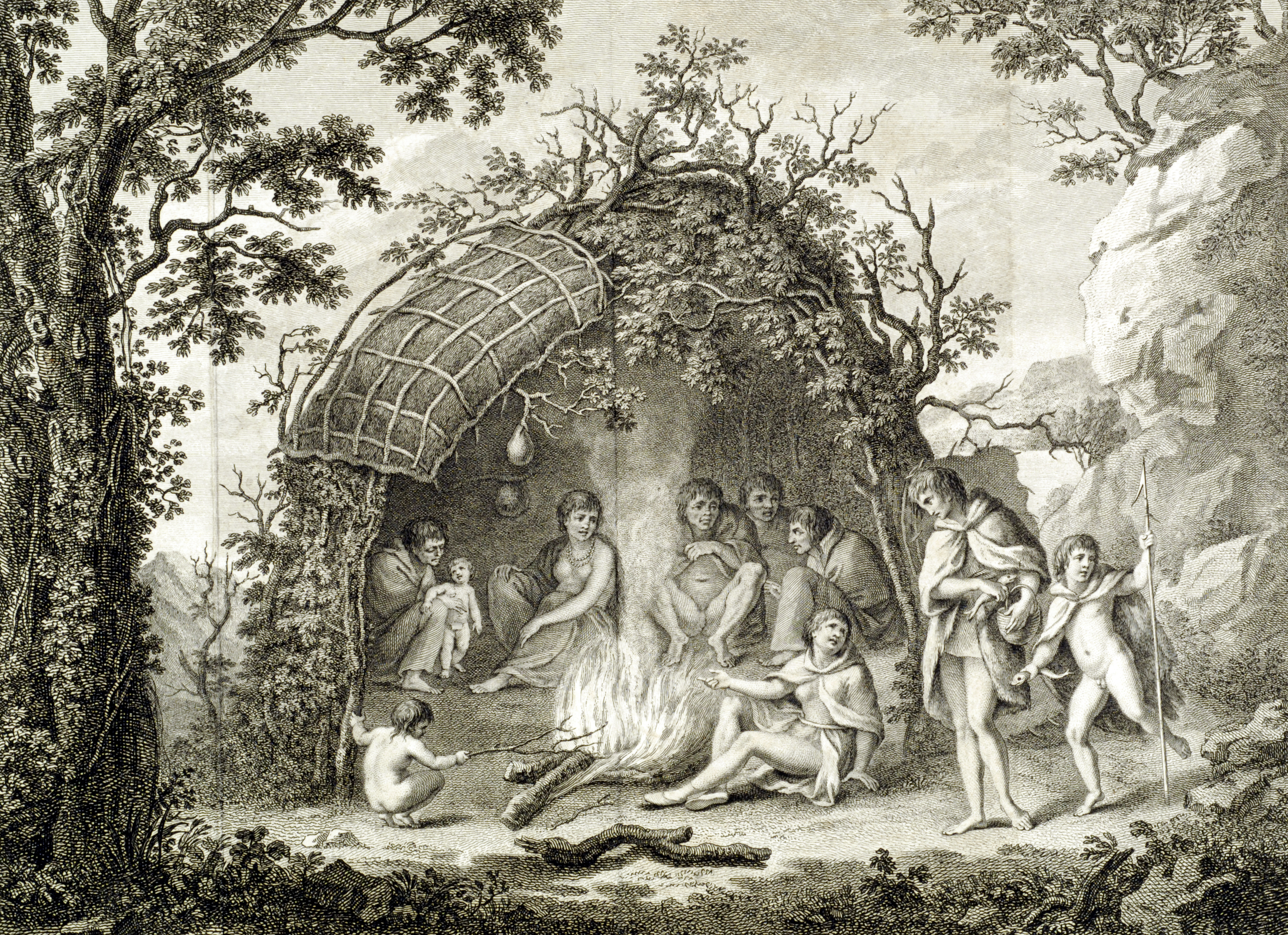
Cook decided to take the route around Cape Horn, rather than dealing with the vicissitudes of the Strait of Magellan, to reach the Pacific. In mid-January, he anchored in what he called the Bay of Success, opposite Staten Island, in the Strait of Le Maire, where the crew traded with the Fuegians. Banks led an exploring party inland but was unprepared for a rapid change of weather that stranded the group overnight in heavy snow and bitter cold. Two of his servants died, but the greyhounds somehow survived.
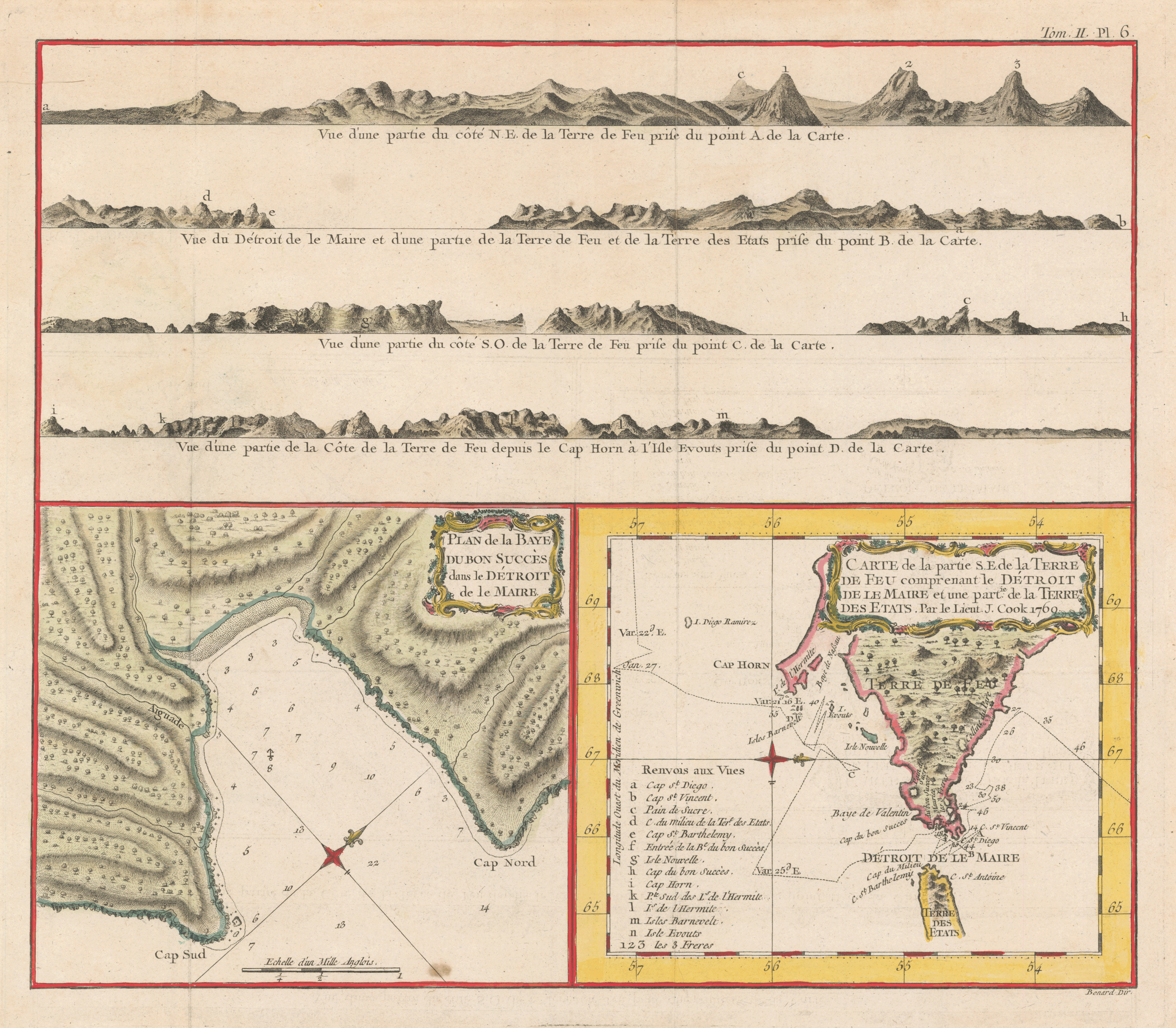
On January 21, 1769, the expedition continued in a southwesterly direction, sighting the 1,400-foot rock triangle of Cape Horn a few days later and, with great surprise, passing it with little danger. Cook fixed it at 55°59′ S, 68°13′ W, remarkably close to its actual position of 55°58′ S, 67°16′ W. He noted that Wallis’s Dolphin had taken three months to pass through the Strait of Magellan during the same part of the year.
The ship rounded Cape Horn and continued westward across the Pacific. The rest of the journey to Tahiti was fairly uneventful, Endeavour arriving in Matavai Bay on April 13, 1769, to a welcoming crowd of canoes. The transit of Venus was scheduled to occur on June 3, and in the meantime Cook commissioned the building of a small fort and observatory at the isolated northern point of the bay which is now known as Point Venus.
Generally, good relations with the Tahitians were maintained, but there were periodic clashes, usually about some theft of expedition supplies or equipment; some nails were removed from the ship’s hull for their iron. Venereal disease appeared to be rampant among the men, but it was really yaws, an endemic disease all over the Pacific, that was treated similarly with arsenic injections.

June 3 dawned crystal clear, and for six hours, in temperatures rising to 119°F, the men did the best they could, but their astronomical observations of Venus were hindered by a dusky cloud surrounding the planet. The astronomer appointed to the task was Charles Green, assistant to the recently appointed Astronomer Royal, Nevil Maskelyne. The primary purpose of the observation was to obtain measurements that could be used to calculate more accurately the distance of Venus from the Sun. If this could be achieved, then the distances of the other planets could be worked out, based on their orbits. On the day of the transit observation, Cook recorded:
“Saturday 3rd This day prov’d as favourable to our purpose as we could wish, not a Clowd was to be seen the Whole day and the Air was perfectly clear, so that we had every advantage we could desire in Observing the whole of the passage of the Planet Venus over the Suns disk: we very distinctly saw an Atmosphere or dusky shade round the body of the Planet which very much disturbed the times of the contacts particularly the two internal ones. D r Solander observed as well as Mr Green and my self, and we differ’d from one another in observeing the times of the Contacts much more than could be expected.“
Disappointingly, the separate measurements of Green, Cook and Solander varied by more than the anticipated margin of error. Their instrumentation was adequate by the standards of the time, but the resolution still could not eliminate the errors. When their results were later compared to those of the other observations of the same event made elsewhere for the exercise, the net result was not as conclusive or accurate as had been hoped. The difficulties are today thought to relate to the Black drop effect, an optical phenomenon that precludes accurate measurement — particularly with the instruments used by Cook, Green and Solander.
Once the observations were completed, Cook opened the sealed orders for the second part of his voyage: to search the south Pacific for signs of the postulated rich southern continent of Terra Australis, acting on additional instructions from the Admiralty.
For a week at the end of the month, Cook, with a small party, took the ship’s pinnace and circled the island so that he could chart it, a rather daring feat considering his vulnerability. Before leaving Tahiti on July 13, he had to deal with an attempted desertion by two crewmen and the kidnap and counterkidnap of Tahitian chiefs and British crew members to resolve this escalating problem. At the last moment, he reluctantly agreed to the addition of Tupaia, a young Tahitian priest and interpreter who wanted to join Banks’s party.
From Tahiti, Cook sailed through and surveyed the rest of what he named the Society Islands , all of which seemed protected by surrounding reefs and home to friendly inhabitants. Endeavour now headed south as Cook turned his attention to finding the Southern Continent. Banks had no doubt of its existence; Cook was very skeptical. The Royal Society, and especially Alexander Dalrymple, believed that it must exist and that Britain’s best chance of discovering it and claiming its fabled riches before any other rival European power managed to do so would be by using Cook’s Transit of Venus mission (on an inconspicuous small ship such as the Endeavour) as a cover.
Day by day the temperature fell, and the livestock (hens and pigs) began dying from the cold and deteriorating fodder. After reaching 40° S, as far south as the Admiralty had instructed, and finding nothing, with the help of a Tahitian named Tupaia who had extensive knowledge of Pacific geography, Cook headed west and managed to reach New Zealand on October 6, 1769, leading only the second group of Europeans to do so (after Abel Tasman over a century earlier, in 1642).
The native Maori they encountered were fierce fighters, and Cook’s attempts to make peace failed— even with Tupaia as translator — resulting in several shootings and deaths, which he deeply regretted. His surveying took him south, then back north, circling what proved to be the northern island in a counterclockwise direction; Endeavour endured some high seas with fearsome rollers. On January 22, 1770, from the top of an island (today’s Arapawa) in Queen Charlotte Sound, Cook realized that a strait separated New Zealand’s two islands; Banks named it Cook Strait in his honor. During inland explorations here, the crew learned of the Maoris’ habit of cannibalizing enemies they killed. In a ceremony on another island-top in the sound, where a cairn was built and a post erected, Cook claimed both big islands for Great Britain.
By rounding the northern island’s southern cape and heading north along its eastern side, actually reaching within sight of their starting point (Cape Turnagain), Cook proved his point without doubt: this was no Southern Continent. From there, his surveying work continued — this time in clockwise direction around the southern island, in the high 40°s and through difficult seas and wind, Banks still hoping this island might be a continent. Cook mapped the complete New Zealand coastline, making only some minor errors (such as calling Banks Peninsula an island, and thinking Stewart Island/Rakiura was a peninsula of the South Island). The weather did not mellow, so Cook was unable to offer the frustrated Banks and his botanical party any time on land until they reached Cook Strait at the end of March and found anchorage on Stephens Island. After gathering wood, filling their water casks, and catching fish, there was no reason to delay their departure, which occurred on March 31, 1770, from Cape Farewell. Cook had decided to return home via the west in order to avoid Cape Horn’s notorious winter and to add opportunities for further exploration.

Cook wrote in his Journal on March 31, 1770, that the Endeavour‘s voyage “must be allowed to have set aside the most, if not all, the Arguments and proofs that have been advanced by different Authors to prove that there must be a Southern Continent; I mean to the Northward of 40 degrees South, for what may lie to the Southward of that Latitude I know not”.
On the same day he recorded his decision to set a course to return home by way of the yet unknown east coast of New Holland (as Australia was then called):
“being now resolv’d [sic] to quit this Country altogether, and to bend my thought towards returning home by such a rout as might Conduce most to the Advantage of the Service I am upon, I consulted with the Officers upon the most Eligible way of putting this in Execution. To return by the way of Cape Horn was what I most wished, because by this rout we should have been able to prove the Existance [sic] or Non-Existance [sic] of a Southern Continent, which yet remains Doubtfull [sic]; but in order to Ascertain this we must have kept in a higher Latitude in the very Depth of Winter, but the Condition of the Ship, in every respect, was not thought sufficient for such an undertaking. For the same reason the thoughts of proceeding directly to the Cape of Good Hope was laid aside, especially as no discovery of any Moment could be hoped for in that rout. It was therefore resolved to return by way of the East Indies by the following rout: upon Leaving this Coast to steer to the Westward until we fall in with the East Coast of New Holland, and then to follow the direction of that Coast to the Northward, or what other direction it might take us, until we arrive at its Northern extremity; and if this should be found impracticable, then to Endeavour [sic] to fall in with the Land or Islands discovered by Quiros“.
A voyage to explore the east coast of New Holland, with a view to a British colonization of the country, had been recommended in John Campbell’s editions of John Harris’s Navigantium atque Itinerantium Bibliotheca, or Voyages and Travels (1744–1748, and 1764), a book which Cook had with him on the Endeavour:
“The first Point, with respect to a Discovery, would be, to send a small Squadron on the Coast of Van Diemen’s Land, and from thence round, in the same course taken by Captain Tasman, by the Coast of New Guiney; which might enable the Nations that attempted it, to come to an absolute Certainty with regard to its Commodities and Commerce… By this means all the back Coast of New Holland, and New Guiney, might be roughly examined; and we might know as well, and as certainly, as the Dutch, how far a Colony settled there might answer our Expectations.“
He then set course westwards, intending to strike for Van Diemen’s Land (present-day Tasmania, sighted by Tasman) to establish whether or not it formed part of the fabled southern continent. However, they were forced to maintain a more northerly course owing to prevailing gales, and sailed onwards until one afternoon when land was sighted, which Cook named Point Hicks. Cook calculated that Van Diemen’s Land ought to lie due south of their position, but having found the coastline trending to the south-west, recorded his doubt that this landmass was connected to it. This point was on the south-eastern coast of the Australian continent, and in doing so his expedition became the first recorded Europeans to have encountered its eastern coastline. In his journal, Cook recorded the event thus:
“the Southermost Point of land we had in sight which bore from us W1/4S I judged to lay in the Latitude of 38°..0′ S° and in the Longitude of 211°..07′ W t from the Meridion of Greenwich. I have named it Point Hicks, because Leuit t Hicks was the first who discover’d this land.”
The ship’s log recorded that land was sighted at 6 a.m. on Thursday April 19, 1770. Cook’s log used the nautical date, which, during the 18th century, assigned the same date to all ship’s events from noon to noon, first p.m. and then a.m. That nautical date began twelve hours before the midnight beginning of the like-named civil date. Furthermore, Cook did not adjust his nautical date to account for circumnavigation of the globe until he had traveled a full 360° relative to the longitude of his home British port, either toward the east or west. Because he traveled west on his first voyage, this a.m. nautical date was the morning of a civil date 14 hours slow relative to his home port (port−14h). Because the south-east coast of Australia is now regarded as being 10 hours fast relative to Britain, that date is now called Friday, April 20.
The landmark of this sighting is generally reckoned to be a point lying about half-way between the present-day towns of Orbost and Mallacoota on the south-eastern coast of the state of Victoria. A survey done in 1843 ignored or overlooked Cook’s earlier naming of the point, giving it the name Cape Everard. On the 200th anniversary of the sighting, the name was officially changed back to Point Hicks.
![Bonne, Rigobert, 1727–1794. “Nlle. Galles Mérid.le [i.e. Nouvelle Galles Méridionale], ou, Côte orientale de la Nouvelle Hollande.” Copperplate map, with added color, 34 × 17 cm. Plate 137 from vol. 2 of R. Bonne and N. Desmarest’s Atlas Encyclopédique . . . (Paris, 1788). Places to note include Botany Bay (B. de Bontanique) around 34°, part of today’s Sydney, highlighted in an inset, and Endeavour River (Riv. Endeavour) at the top, between 15° and 16°, where the ship was repaired. The large inset at the bottom left shows the part of Tasmania explored by Captain Tobias Furneaux of the Adventure during Cook’s second voyage.](https://farm5.staticflickr.com/4384/36648220142_d4bcdceb6a_o.jpg)
Endeavour continued northwards along the coastline, keeping the land in sight with Cook charting and naming landmarks as he went. A little over a week later, they came across an extensive but shallow inlet, and upon entering it moored off a low headland fronted by sand dunes. James Cook and crew made their first landing on the continent, at a place now known as Botany Bay, on the Kurnell Peninsula and made contact of a hostile nature with the Gweagal Aborigines, on April 29. At first, Cook bestowed the name “Sting-Ray Harbour” to the inlet after the many such creatures found there; this was later changed to “Botanist Bay” and finally Botany Bay after the unique specimens retrieved by the botanists Joseph Banks, Daniel Solander and Herman Spöring.
This first landing site was later to be promoted (particularly by Joseph Banks) as a suitable candidate for situating a settlement and British colonial outpost. However, almost 18 years later, when Captain Arthur Phillip and the First Fleet arrived in early 1788 to establish an outpost and penal colony, they found that the bay and surrounds did not live up to the promising picture that had been painted. Instead, Phillip gave orders to relocate to a harbor a few miles to the north, which Cook had named Port Jackson but had not further explored. It was in this harbor, at a place Phillip named Sydney Cove, that the settlement of Sydney was established. The settlement was for some time afterwards still referred to generally as Botany Bay. The expedition’s scientific members commenced the first European scientific documentation of Australian fauna and flora.
At Cook’s original landing contact was made with the local Australian Aboriginal inhabitants. As the ships sailed into the harbor, they noticed Aborigines on both of the headlands. At about 2 pm they put the anchor down near a group of six to eight huts. Two Aborigines, a younger and an older man, came down to the boat. They did not accept the offer of gifts from Cook, whose lack of knowledge of Aboriginal custom may have prevented him from behaving acceptably in such exchanges. A musket was fired over their heads, which wounded the older man slightly, and he ran towards the huts. He came back with other men and threw spears at Cook’s men, although they did no harm. They were chased off after two more rounds were fired. The adults had left, but Cook found several Aboriginal children in the huts, and left some beads with them as a gesture of friendship.
Through May and into June, Endeavour sailed north, arcing northwest, following the Great Barrier Reef coastline. He stopped at Bustard Head on May 24. Cook and Banks and others went ashore. On the evening of June 10, 1770, when most of the men were sleeping, the ship struck coral, stuck fast, and began leaking. Quick thinking and decisive action by Cook and his men — pumping furiously and jettisoning fifty tons of decayed stores, stone ballast, and cannons — kept the ship afloat and allowed a temporary underwater repair. A few days later, the damaged ship was safely beached on a barren shore (near the docks of modern Cooktown, at the mouth of the Endeavour River), and a fury of activity began more permanent work: the expedition had avoided a real disaster. Henceforth, the British Admiralty would send Cook out with two ships for safety.
While there, Joseph Banks, Herman Spöring and Daniel Solander made their first major collections of Australian flora. The crew’s encounters with the local Aboriginal people were mainly peaceable; from the group encountered here the name “kangaroo” entered the English language, coming from the local Guugu Yimidhirr word for a kind of Grey Kangaroo, gangurru, By August 13, the ship was ready to resume its journey.
The labyrinth of treacherous islands and reefs was threaded slowly and carefully, with vigilance and some luck, as the expedition sailed northward through the Great Barrier Reef, eventually passing by the northernmost point of Cape York Peninsula and then sailing through Torres Strait between Australia and New Guinea, earlier navigated by Luis Váez de Torres in 1606. In negotiating the Torres Strait past Cape York, Cook put an end to the speculation that New Holland and New Guinea were part of the same land mass. Having rounded the Cape, Cook stopped briefly at Possession Island (his name) on August 22. Knowing he was in territory explored by the Dutch, he claimed the whole coastline he had just charted for King George III (later naming the region New South Wales) for the British Crown. It was a proud moment, essentially marking the end of Cook’s first Pacific voyage’s geographical discoveries.
At that point in the voyage Cook had lost not a single man to scurvy, a remarkable and practically unheard-of achievement in 18th century long-distance seafaring. Adhering to Royal Navy policy introduced in 1747, Cook persuaded his men to eat foods such as citrus fruits and sauerkraut. At that time it was known that poor diet caused scurvy but not specifically that a vitamin C deficiency was the culprit.
Sailors of the day were notoriously against innovation, and at first the men would not eat the sauerkraut. Cook used a “method I never once knew to fail with seamen.” He ordered it served to himself and the officers, and left an option for crew who wanted some. Within a week of seeing their superiors set a value on it the demand was so great a ration had to be instituted. In other cases, however, Cook was required to resort to traditional naval discipline. “Punished Henry Stephens, Seaman, and Thomas Dunster, Marine, with twelve lashes each for refusing to take their allowance of fresh beef.”
Cook’s general approach was essentially empirical, encouraging as broad a diet as circumstances permitted, and collecting such greens as could be had when making landfall. All onboard ate the same food, with Cook specifically dividing equally anything that could be divided.
Two cases of scurvy did occur on board, astronomer Charles Green and the Tahitian navigator Tupaia were treated, but Cook was able to proudly record that upon reaching Batavia he had “not one man upon the sick list”, unlike so many voyages that reached that port with much of the crew suffering illness.
The Endeavour then visited the island of Savu, staying for three days before continuing on to Batavia (today’s Jakarta, Indonesia), the capital of the Dutch East Indies, to put in for repairs. In Batavia, where Endeavour anchored on October 7, 1770, there was English news. American colonists had refused to pay taxes, and the king had dispatched troops to put down the first signs of a rebellion.
Now, in one of the most diseased foreign cities, malaria, dysentery, and other ills began their work: almost everyone got sick during the months they remained on the island for refit and repair, and many in Cook’s company succumbed to ailments, including the Tahitian Tupaia, Banks’ Finnish secretary and fellow scientist Herman Spöring, astronomer Charles Green, and the illustrator Sydney Parkinson. Cook named Spöring Island off the coast of New Zealand to honor Herman Spöring and his work on the voyage.
Even after Cook left for home on December 26, 1770, the unfortunate deaths continued — thirty-four in all by the time they reached Cape Town in March — and five more would die there or on the last leg back to England. Cook then rounded the Cape of Good Hope and stopped at Saint Helena. On July 10, 1771, Nicholas Young, the boy who had first seen New Zealand, sighted England (specifically the Lizard) again for the first time, and the Endeavour sailed up the English Channel, passing Beachy Head at 6 am on July 12; that afternoon Endeavour anchored in the Downs, and Cook went ashore at Deal, Kent. Never failing to provide milk for the officers, Wallis’s goat was among the elite, having survived its second circumnavigation.
Cook’s return was unexpected, as newspapers and journals had long since reported fears that Endeavour had been lost at sea or destroyed in combat against the French.
The three men — Cook, Banks, and Solander — companions during more than a thousand days at sea, now shared a seven-hour post-chaise trip through Kent to London, riding into history. The botanists had brought back a wealth of scientific data about plant and animal species, including thousands of plants never seen in England as well as the amazing drawings of Sydney Parkinson and Alexander Buchan, the expedition’s artists, who had both died on the voyage. Cook had recorded his observations of the life and customs of the Polynesians of Tahiti, the Maori of New Zealand, and the Aborigines of Australia. And he had his accurate charts, which would immediately improve the mapping of the Pacific Ocean.
Approximately one month after his return, Cook was promoted to the rank of Commander, and by November 1771 was in receipt of Admiralty Orders for a second expedition, this time aboard HMS Resolution. He was killed during an altercation with Hawaiians at Kealakekua Bay on February 14, 1779.
Cook’s journals, along with those of Banks, were handed over to the Admiralty to be published upon his return. Lord Sandwich contracted, for £6,000, John Hawkesworth a literary critic, essayist, and editor of The Gentleman’s Magazine to publish a comprehensive account of exploration in the Pacific: not just Cook’s ventures but also those of Wallis, Byron and Carteret. Hawkesworth edited the journals of Byron, Wallis and Carteret into separate accounts as volume I and then blended Cook’s and Joseph Banks’ journals with some of his own sentiments and produced a single first-person narrative that appeared to be the words of Cook, as Volume II. The book appeared in 1773 as three volumes with the title:
AN ACCOUNT OF THE VOYAGES undertaken by Order of His Present Majesty for making Discoveries in the Southern Hemisphere, and successively performed by Commodore Byron, Captain Wallis, Captain Carteret and Captain Cook, in the Dolphin, the Swallow and the Endeavour: Drawn up from the Journals which were kept by the several Commanders, and from the Papers of Joseph Banks, Esq.; by John Hawkesworth, LL.D. In three volumes. Illustrated with Cuts, and a great Variety of Charts and Maps relative to Countries now first discovered, or hitherto but imperfectly known.
Printed for W. Strahan & T. Cadell in the Strand. London: MDCCLXXIII
The book went on sale on June 9, 1773, but widespread criticism in the press made the publication a personal disaster for Hawkesworth. Reviewers complained that the reader had no way to tell which part of the account was Cook, which part Banks and which part Hawkesworth and others were offended by the books’ descriptions of the voyagers’ sexual encounters with the Tahitians. Cook was at sea again before the book was published and was later much disturbed by some of the sentiments that Hawkesworth has ascribed to him. He determined to edit his own journals in future. Cooks’ journal of the voyage as well as those of Joseph Banks and Sydney Parkinson can be found online on the South Seas website alongside all three volumes of Hawkesworth’s account.

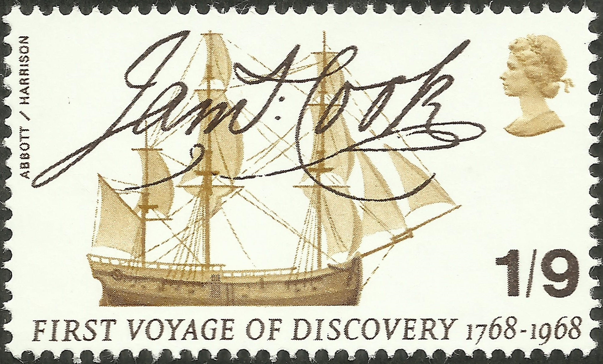
Scott #567 was issued by Great Britain’s Royal Mail on May 28, 1968, to commemorate the 200th anniversary of James Cook’s first voyage of discovery. The 1 shilling 9 pence black and bister stamp, perforated 14½x14, depicts a profile view of Endeavour along with Cook’s signature. The ship was originally the merchant collier Earl of Pembroke, built by Thomas Fishburn for Thomas Millner, launched in June 1764 from the coal and whaling port of Whitby in North Yorkshire, of a type known locally as the Whitby Cat. She was ship-rigged and sturdily built with a broad, flat bow, a square stern, and a long box-like body with a deep hold.
A flat-bottomed design made her well-suited to sailing in shallow waters and allowed her to be beached for loading and unloading of cargo and for basic repairs without requiring a dry dock. Her hull, internal floors, and futtocks were built from traditional white oak, her keel and stern post from elm, and her masts from pine and fir. Plans of the ship also show a double keelson to lock the keel, floors and frames in place.
While Cook was fêted for his successful voyage, Endeavour was largely forgotten. Within a week of her return to England, she was directed to Woolwich Dockyard for refitting as a naval transport. Under the command of Lieutenant James Gordon, she then made three return voyages to the Falkland Islands.
The first, with Joseph Irving as sailing master (replaced by John Dykes at Portsmouth due to illness), was to deliver “sufficient provisions to serve 350 men to the end of the year 1772”; she sailed from Portsmouth on November 8, 1771, but due to terrible weather did not arrive at Port Egmont (the British base in the Falkland Islands) until March 1. Endeavour sailed from Port Egmont on May 4 in a three-month non-stop voyage until she anchored at Portsmouth.
The second voyage was to reduce the garrison and replace HM Sloop Hound, John Burr Commander, with a smaller vessel, namely the 36-ton shallop Penguin, commander Samuel Clayton. She was a collapsible vessel and was no sooner built than taken apart, and the pieces were stowed in Endeavour. Endeavour sailed in November with Hugh Kirkland as the sailing master, and additionally the crew of Penguin, and four ship’s carpenters whose job was to reassemble Penguin on arrival, which was January 28, 1773. On April 17, Endeavour and Hound sailed for England with their crew.
The third voyage sailed in January 1774 and her purpose was to evacuate the Falklands entirely as Britain was faced with political difficulties from the American Colonies, the French and the Spanish. The government thought that if British ships and troops were engaged in America, Spain might seize the Falklands, capturing the small garrison at Port Egmont and maybe killing some of them — this, it was feared, would trigger an outcry which might topple the government. Endeavour sailed from the Falklands with all the British inhabitants on April 23, 1774, leaving a flag and a plaque.
The ship was paid off in September 1774, and in March 1775 was sold by the Navy to shipping magnate J. Mather for £645. Mather returned her to sea for at least one commercial voyage to Archangel in Russia.
Once the American War of Independence had commenced, the British government needed ships to carry troops and materiel across the Atlantic. In 1775, Mather submitted Endeavour as a transport ship, and she was rejected. Thinking that renaming her would fool Deptford Yard, Mather resubmitted Endeavour under the name Lord Sandwich. The ship was rejected in no uncertain terms: “Unfit for service. She was sold out Service Called Endeavour Bark refused before”. Lord Sandwich then had serious repairs, and on her third submission was accepted and was termed Lord Sandwich 2 as there was already a transport ship by the same name.
Lord Sandwich 2, master William Author, sailed on May 6, 1776 from Portsmouth in a fleet of 100 vessels, 68 of which were transports, which was under orders to support Howe’s campaign to capture New York. Lord Sandwich 2 carried 206 men mainly of the Hessian du Corps regiment of Hessian mercenaries. The crossing was terrible, and two Hessians who were in the same fleet have left us accounts of the voyage. The scattered fleet assembled at Halifax and then sailed to Sandy Hook where other ships and troops assembled. On August 15, 1776, Lord Sandwich 2 was anchored at Sandy Hook; also assembled there was Adventure (which had sailed with Resolution on Cook’s second voyage), now a storeship, captain John Hallum. Another ship there at that time was HMS Siren, captain Tobias Furneaux, who had commanded Adventure on the second voyage.
New York was eventually captured, but Newport, Rhode Island, in the hands of the Americans posed a threat as a base for recapturing New York, so in November 1776 a fleet, which included Lord Sandwich 2 carrying Hessian troops, set out to take Rhode Island, which was taken but not subdued. The ship was then used as a floating prison.
The surrender of Burgoyne’s army at Saratoga, brought France into the war, and in the summer of 1778 a pincer plan was agreed to recapture Newport: the Continental Army would approach overland, and a French Fleet would sail into the harbor. To prevent the latter, the British commander, Captain John Brisbane, determined to blockade the bay by sinking surplus vessels at its mouth. Between August 3 and 6, a fleet of Royal Navy and hired craft, including Lord Sandwich 2, were scuttled at various locations in the Bay. Lord Sandwich 2, previously Endeavour, previously Earl of Pembroke, was sunk on August 4, 1778.
The owners of the sunken vessels were compensated by the British government for the loss of their ships. The Admiralty valuation for 10 of the sunken vessels recorded that many had been built in Yorkshire, and the details of the Lord Sandwich transport matched those of the former Endeavour including construction in Whitby, a burthen of 36871⁄94 tons, and re-entry into Navy service on February 10, 1776.
In 1834, a letter appeared in the Providence Journal of Rhode Island, drawing attention to the possible presence of the former Endeavour on the seabed of the bay. This was swiftly disputed by the British consul in Rhode Island, who wrote claiming that Endeavour had been bought from Mather by the French in 1790 and renamed Liberté. The consul later admitted he had heard this not from the Admiralty, but as hearsay from the former owners of the French ship. It was later suggested Liberté, which sank off Newport in 1793, was in fact another of Cook’s ships, the former HMS Resolution, or another Endeavour, a naval schooner sold out of service in 1782. A further letter to the Providence Journal stated that a retired English sailor was conducting guided tours of a hulk on the River Thames as late as 1825, claiming that the ship had once been Cook’s Endeavour.
In 1991, the Rhode Island Marine Archaeology Project (RIMAP) began research into the identity of the thirteen transports sunk as part of the Newport blockade of 1778, including Lord Sandwich. In 1999, RIMAP discovered documents in the Public Record Office (now called the National Archives) in London confirming that Endeavour had been renamed Lord Sandwich, had served as a troop transport to North America, and had been scuttled at Newport as part of the 1778 fleet of transports.
In 1999 a combined research team from RIMAP and the Australian National Maritime Museum examined some known wrecks in the harbor and in 2000, RIMAP and the ANMM examined a site that appeared to be one of the blockade vessels, partly covered by a separate wreck of a 20th century barge. The older remains were those of a wooden vessel of approximately the same size, and possibly a similar design and materials as Lord Sandwich ex Endeavour. Confirmation that Cook’s former ship had indeed been in Newport Harbor sparked considerable media and public interest in confirming her location. However, further mapping showed eight other 18th century wrecks in Newport Harbor, some with features and conditions also consistent with Endeavour. In 2006, RIMAP announced that the wrecks were unlikely to be raised. In 2016. RIMAP concluded that there was a probability of 80 to 100% that the wreck of Endeavour was still in Newport Harbor, probably one of a cluster of five wrecks on the seafloor, and planned to investigate the ships and their artifacts further. They were seeking funds to build facilities for handling and storing recovered objects.
In addition to the search for the remains of the ship herself, there was considerable Australian interest in locating relics of the ship’s south Pacific voyage. In 1886, the Working Men’s Progress Association of Cooktown sought to recover the six cannons thrown overboard when Endeavour grounded on the Great Barrier Reef. A £300 reward was offered for anyone who could locate and recover the guns, but searches that year and the next were fruitless and the money went unclaimed. Remains of equipment left at Endeavour River were discovered around 1900, and in 1913 the crew of a merchant steamer erroneously claimed to have recovered an Endeavour cannon from shallow water near the Reef.
In 1937, a small part of Endeavour‘s keel was gifted to the Australian Government by philanthropist Charles Wakefield in his capacity as president of the Admiral Arthur Phillip Memorial. Australian Prime Minister Joseph Lyons described the section of keel as “intimately associated with the discovery and foundation of Australia”.
Searches were resumed for the lost Endeavour Reef cannons, but expeditions in 1966, 1967, and 1968 were unsuccessful. They were finally recovered in 1969 by a research team from the American Academy of Natural Sciences, using a sophisticated magnetometer to locate the cannons, a quantity of iron ballast and the abandoned bower anchor. Conservation work on the cannons was undertaken by the Australian National Maritime Museum, after which two of the cannons were displayed at its headquarters in Sydney’s Darling Harbour, and eventually put on display at Botany Bay and the National Museum of Australia in Canberra (with a replica remaining at the museum). A third cannon and the bower anchor were displayed at the James Cook Museum in Cooktown, with the remaining three at the National Maritime Museum in London, the Academy of Natural Sciences in Philadelphia, and the Museum of New Zealand Te Papa Tongarewa in Wellington.
Endeavour‘s Pacific voyage was further commemorated in the use of her image on the reverse of the New Zealand fifty-cent coin, and in the naming of the Space Shuttle Endeavour in 1989.
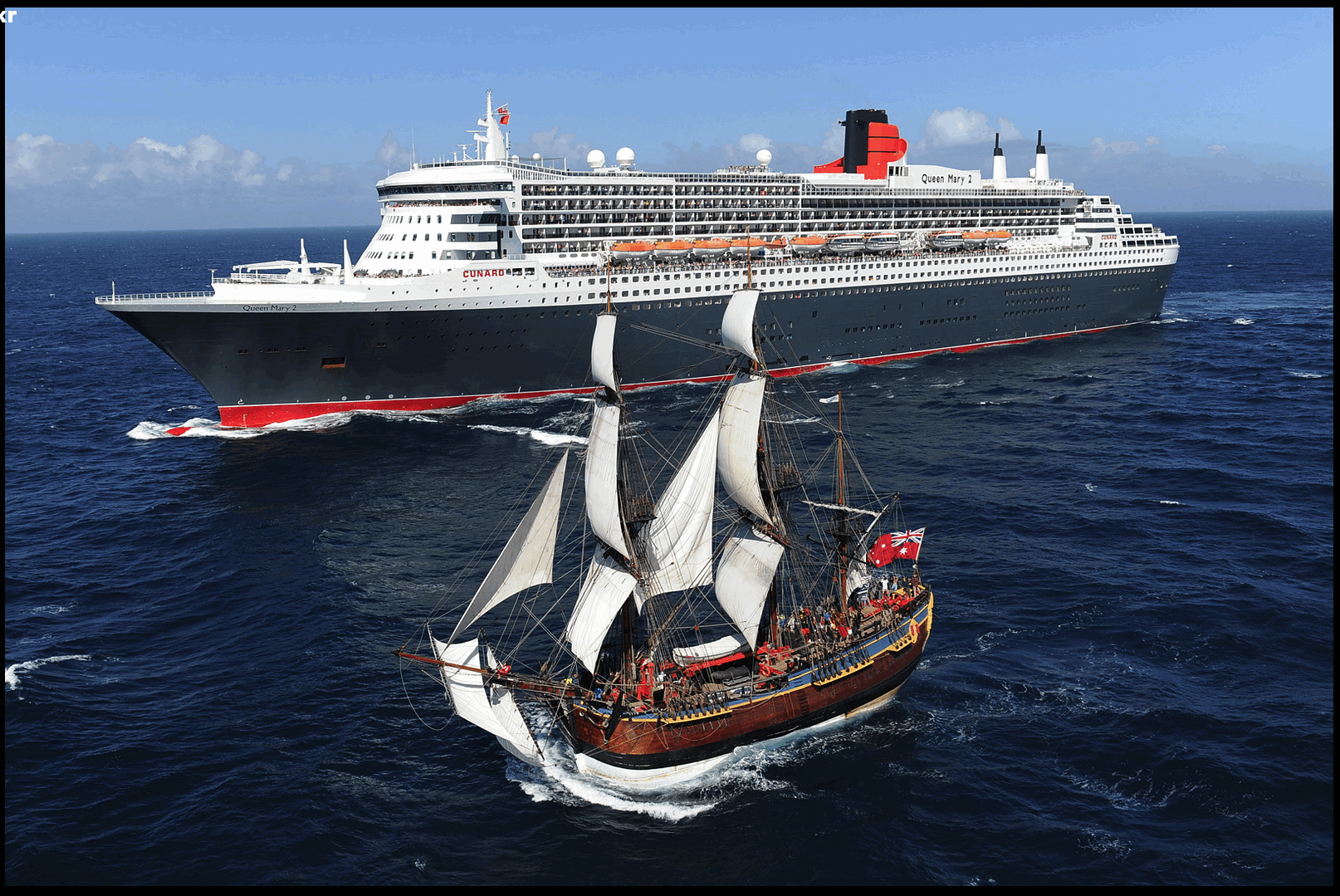
In January 1988, to commemorate the Australian Bicentenary of European settlement in Australia, work began in Fremantle, Western Australia, on a replica of Endeavour. Financial difficulties delayed completion until December 1993, and the vessel was not commissioned until April 1994. The replica vessel commenced her maiden voyage in October of that year, sailing to Sydney Harbour and then following Cook’s path from Botany Bay northward to Cooktown. From 1996 to 2002, the replica retraced Cook’s ports of call around the world, arriving in the original Endeavour‘s home port of Whitby in May 1997 and June 2002. Footage of waves shot while rounding Cape Horn on this voyage was later used in digitally composited scenes in the 2003 film Master and Commander: The Far Side of the World.
The replica Endeavour visited various European ports[118] before undertaking her final ocean voyage from Whitehaven to Sydney Harbour on November 8, 2004. Her arrival in Sydney was delayed when she ran aground in Botany Bay, a short distance from the point where Cook first set foot in Australia 235 years earlier. The replica Endeavour finally entered Sydney Harbour on April 17, 2005, having traveled 170,000 nautical miles (310,000 km), including twice around the world. Ownership of the replica was transferred to the Australian National Maritime Museum in 2005 for permanent service as a museum ship in Sydney’s Darling Harbour.
A second full-size replica of Endeavour is berthed on the River Tees in Stockton-on-Tees. While this reflects the external dimensions of Cook’s vessel, this replica was constructed with a steel rather than a timber frame, has one less internal deck than the original, and is not designed to be put to sea. The Russell Museum, in the Bay of Islands, New Zealand, has a seagoing one-fifth scale replica of Endeavour. It was built in Auckland; during 1969 and 1970 it sailed some 15,000 miles (24,000 km) in New Zealand and Australia. At Whitby, the Bark Endeavour Whitby is a scaled-down replica of the original ship. It relies on engines for propulsion and is a little less than half the size of the original. Trips for tourists take them along the coast to Sandsend.


Love your work! Thank you!
LikeLike